Imago Mundi
هيئة الأرض
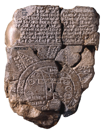
a, b Babylonian World Map
The map of the ancient world (7.6 × 6.8 cm) or Imago Mundi, as drawn by the Babylonians in the 9th century BC (Other research places it between the eighth, seventh and sixth centuries BC) As shown in the sketch (Fig. b), Babylon on the Euphrates River is the center of the ancient world. Other cities such as Susa, Ur, and Urartu are also shown, as are the marshlands (Ahwār), and mountains surrounding Babylonia, while the Muraratum (Bitter River = the ocean) surrounds the whole of Mesopotamia, and behind all are six or seven foreign regions representing the nations of the ancient world.

c Map of the ancient world according to Anaximander
Anaximander was a Greek philosopher who lived between ~611 – 547 BC. He was known for his work in investigating the universe, trying to understand its spaces and drawing maps of the world.
Born in Miletus, he was a student of Thales. Anaximander was interested in geometry and invented the sundial for the first time in the ancient Greek world. Many tend to consider him the first to draw a map of the ancient inhabited world that agrees with the
geographical measurements that would be known later, although his map was lost over time, but it was reconstructed according to his vision. He believed that the Earth floats in an infinite, unlimited space where opposites meet (cold and hot, dry and wet, etc.) and is not supported by anything, unlike his teacher Thales, who believed that it floats on water.
d Map of the ancient world according to Hecataeus

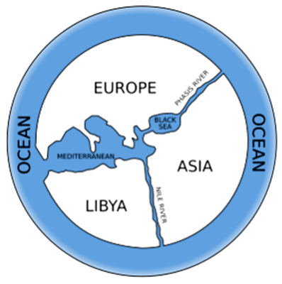
Hecataeus lived in the sixth century BC. (~550- 476 BC.) He improved the map of Anaximander who saw the earth as a circular disk surrounded by the ocean; the two maps do not differ in the main structure, but Hecataeus attached his map to a considerable volume in which he mentioned the countries and regions of the Oikoumen and the nature of their inhabitants and made Greece the center of the map. Herodotus later corrected the features of the map based on his travels, so he surrounded the earth with seas from three directions and in the fourth direction he made the desert extend to the east without borders.
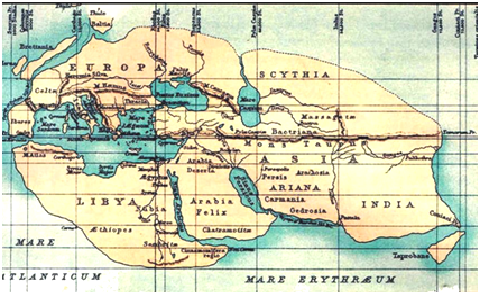
e Map of the ancient world according to Eratosthenes of Cyrene
Eratosthenes was born in Cyrene (Libya), and moved to Alexandria where he became the head of its librarians after being appointed by Ptolemy III. It is said that he was a close friend of Archimedes. Eratosthenes was famous for his brilliance in mathematics. He was also the first to establish the science of geography, and drew a detailed map of the world based on the information available to him at that time. His method of determining the size of the Earth was a clever application of simple geometry to a very complex and difficult problem at the time. Although he made some assumptions, his calculations gave accurate values. What is even more amazing is that the calculations he made did not take him much time.

Eratosthenes learned that the sun is perpendicular to the city of Aswan (northern Egypt) after he learned that the vertical bars of a temple in southern Aswan do not cast shadows at noon on June 21, and that the shadows of the temple get shorter and shorter as the time approaches midday until they disappear completely at midday. His hypotheses led him to conduct an experiment to find out whether the vertical bars in Alexandria cast shadows at the same time, June 21, and discovered that they cast shadows, unlike the case in Aswan.
This experiment led him to conclude that the Earth is spherical. If the Earth were flat, the sun’s rays would make the columns in Aswan and Alexandria cast the same shadows, and the difference in shadows could only be explained by the Earth being convex, such that the sun’s rays create a different angle with the columns in Aswan than those in Alexandria. Eratosthenes also concluded that the angle between Aswan and Alexandria is 7.2 degrees along the Earth’s surface (if we draw two straight lines, from Alexandria and Aswan, heading toward the center of the Earth, the angle between the two lines is 7.2 degrees), which constitutes about one-fiftieth of the Earth’s circumference (360 degrees.) Eratosthenes measured the angle in a simple geometric way, where he measured the length of a stick and placed it perpendicular to the ground in Alexandria, and measured the shadow when the sun was completely perpendicular to Aswan. From knowing the length of the shadow and the actual length of the stick according to the angle of the sun’s inclination, using the known trigonometry. Eratosthenes also knew that the distance between Aswan and Alexandria was 800 kilometers by assigning a man to measure the distance by steps walking from one city to the other.

By calculating the distance between Alexandria and Aswan (800 kilometers), and the angle between them by guesstimating directions toward the center of the earth (7.2 degrees), and the total angle of the circle being 360 degrees, the total circumference of the Earth would be equal to the result of dividing 360/7.2 multiplied by the distance between the two cities, i.e. 800 kilometers. Thus, he concluded from these calculations that the circumference of the Earth is 40,000 kilometers.
Actually, the circumference of the Earth is only 66 kilometers larger, meaning the error rate in Eratosthenes’ calculations was very slight considering the primitive tools he used 2200 years ago. This is truly amazing.
If we think about the reason for the slight difference in Eratosthenes’ calculations from the currently known value, we find that it is related to the assumptions he made, as he thought that the sun’s rays reach the two cities (Aswan and Alexandria) in parallel on the basis that the sun is located very far from the earth, and the distance between Aswan and Alexandria is very small when compared to the circumference of the earth, thus this distance can be treated as flat, while it is an arc in a large circle. It is worth mentioning here that Christopher Columbus studied Eratosthenes’ calculations about the circumference of the earth, but instead of adopting them, he was more inclined to believe that the circumference of the earth is much smaller than that, according to the expectations of the Italian astronomer Toscanelli, who made the circumference of the earth about 33% smaller than what was stated in Eratosthenes’ calculations. This encouraged Columbus to set sail. If he had believed Eratosthenes’ calculations, he would have known that he had reached the New World, not Asia
Eratosthenes of Cyrene lived from 276 to 195/194 BC. But his geographical theory later influenced one of the most important geographers of the ancient world in the second century AD, Claudius Ptolemy, who created an innovative map of twenty-six sections, a map that would continue to be influential and adopted until the Middle Ages.
